Τρίτη 5 Νοεμβρίου 2013

Spinalonga, Crete, Greece

Spinalonga
The island of Spinalonga, officially known as Kalydon, is located in the Gulf of Elounda in north-eastern Crete,  next to the town of Elounda. Originally, Spinalonga was not an island, it was part of the island of Crete. During Venetian occupation the island was carved out of the coast for defense purposes and a fort was built there. During Venetian rule, salt was harvested from salt pans around the island.

The island of Spinalonga
But the reason that makes this island so unique is that it has been used as a leper colony from 1903 to 1957. It is notable for being one of the last active leper colonies in Europe. The last inhabitant, a priest, left the island in 1962. There were two entrances to Spinalonga, one being the lepers' entrance, a tunnel known as "Dante's Gate". This was so named because the patients did not know what was going to happen to them once they arrived. However, once on the island they received food, water, medical attention and social security payments.

Dante's Gate

Bottles of medicines used in Spinalonga
Today, the uninhabited island is a popular tourist attraction in Crete. In addition to the abandoned leper colony and the fortress, Spinalonga is known for its small pebble beaches and shallow waters. The island can easily be accessed from Elounda and Agios Nikolaos. Tourist boats depart from both towns on a daily basis. There is no accommodation on Spinalonga, meaning all tours last only a few hours.

The uninhabited island of Spianlonga
 Spinalonga featured in the British television series "Who Pays the Ferryman?" and Werner Herzog's experimental short film "Last Words".  It is also the setting for the 2005 novel "The Island" by Victoria Hislop, the story of a family's ties to the leper colony. The book was adapted for television by Mega Channel Greece. 

Scene of Mega Channel's production
The castle of Spinalonga

 Panoramic:

Πέμπτη 31 Οκτωβρίου 2013

Elafonisos, Lakonia, Greece


Elafonisos is a beautiful island located at the southeastern tip of the Peloponnese, only 570 meters from the opposite Peloponnesian coast. In antiquity, Elafonisos did not constitute an island but a peninsula with the name "Onou Gnathos". 

On the way to Sarakiniko beach (Paradise)

The village of Elafonisos

The population is between 300 and 350 during the winter but increases dramatically in the summer months. During July and August the number of tourist visitors reach over 3,000 per day. Many people visit the island for its light coloured, sandy beaches. Among the most well known of its beaches are Sarakiniko, Fragos (Simos) and Panagias Nissia, all filled with blue-green waters.

The twin beaches of Sarakiniko and Simos
The crystal clear sea of Elafonisos

The current name the Elafonissos (Island of the Deers), according to research of Stamoulis Iakovos and Kroupis Ilias, is due to the rich hunting that existed in the region from the antiquity as it is reported by the Pausanias there was a statuary of Artemis (Goddess of hunting) in the region. Also, the existence of a population of deers of red colour.

Agios Spyridonas, Elafonisos

Frango (Simos)- Saracenico
This is the majestic twin beaches, the small and large bays on the south eastern tip of the island, opposite the Kythera and the Spathi tip. The amazing colours of the sea, a combination with thin light gold coloured sand Unique are the Cedar trees which can be found in Simos, Panagia ta Nisia, Megalo tigani and Kalogeras. In August, in the sand of beach blossom the sandy crinum, which you are advised not to cut, so it's seeds fertise.

The twin beaches


Where to stay


Elafonisos, Greece

Παρασκευή 18 Οκτωβρίου 2013

Meteora, Thessaly, Greece

Meteora
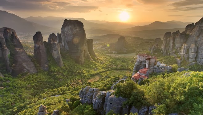
Meteora is a cluster of huge dark cliffs of sandstone which are rising out of Kalambaka, near the first hills of Pindos and Hasion. The monasteries of Meteora, which are built on the top of some of the rocks, are currently the second most important group of monasteries in Greece after Mount Athos.
The six visited monasteries of Meteora, are now restored and most of their mural decoration is preserved.
 
The monastery of Agios Stefanos
The monastery of Rossanos


Meteora
The creation of this geological landscape, although it has occasionally been a benchmark for many Greek and foreign geologists, it's not yet clearly understood. The lofty, cut off between them, rocks, whose height reaches sometimes 400 meters, is a unique geological phenomenon, covering an area of ​​about thirty kilometers.

Transportation between the rocks
Meteora attracts a lot of extreme sports fans
In 1989 Unesco inscribed Meteora in the list of UNESCO World Heritage, as a particularly important cultural and natural resource.

Falling stars in Meteora
Meteora during winter


The breathtaking view of Meteora


Δευτέρα 7 Οκτωβρίου 2013

Mount Athos, Ηalkidiki, Greece

Simonopetra Monastery
Mount Athos is a self-governed part of the Greek state, located on the Athos peninsula of Halkidiki in Macedonia. The Athos peninsula is the easternmost and rougher of the three individual parallel peninsulas that form up the peninsula of Halkidiki. There is situated the mount Athos, hence it's name.  

Athos Peninsula
Includes twenty Holy Monasteries and other monastic institutions and is informally characterized as "Autonomous Monastic State." It is the center of Orthodox Christian monasticism with great monuments of historical, religious, secretarial and cultural value, on a global scale.

Monastery of Vatopedi
 
Monasticism on Mount Athos began around the 8th century and since then it's the most important monastic center of the world.

Although it's administrated under the supervision of the Greek State, spiritually is under the supreme authority of the Ecumenical Patriarchate of Constantinople. Across the whole region of Athos the "avato" is applied. This means that no female is allowed to enter in this territory. This restriction has it's spiritual base in the chastity of the monks. Nevertheless, the monasteries accept male visitors of any religious beliefs.


Monk in Simonopetra Monastery
 Since 1988 Mount Athos is part of the World Heritage Sites list.

Koutloumousiou monastery


Τρίτη 1 Οκτωβρίου 2013

Monemvasia, Lakonia, Greece

Rock of Monemvasia
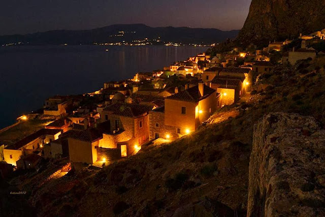
Monemvasia is a small historic town in eastern Peloponnese, in the region of Laconia. It is better known by the medieval fortress on the "Rock of Monemvasia", which is literally an island, connected to the mainland by a 400 meter length bridge. 

Monemvasia
The old town of Monemvasia, situated on the rock, is a perfectly preserved medieval settlement still inhabited, a world cultural heritage monument and a major attraction for every traveler in the Peloponnese. It has a unique, magical atmosphere and a fascinating history.

Byzantine church in Monemvasia
The preserved buildings and structures include defensive structures of the outer castle and several small Byzantine churches and monuments, which are scattered throughout the old town (castle).

View from the top of the rock

An alley in Monemvasia
Monemvasia's nickname is "Gibraltar of the East", because it happens to be identical to the rock of Gibraltar. Today, it has 4.660 inhabitants, including the inhabitants of the new town of Monemvasia which is situated at the other end of the causeway on the mainland. It is easily accessible by car. However, cars are not allowed inside the old town, where you can only find small alleys with restaurants, hotels and souvenirs shops.

Monemvasia at night

Monemvasia, Greece

Δευτέρα 30 Σεπτεμβρίου 2013

Pyrgi, Chios, Greece

Travelling to Chios, the fifth largest of the Greek islands, situated in the Aegean sea, will definitely be an unforgettable experience. Chios is just a few kilometers away from Minor Asia and it's famous for the mastic trees (which are unique in the world), the shipping quality and its beautiful villages.

Mastic trees
Mastic
Pyrgi is the biggest and one of the most famous villages of Chios. Situated on the south of the island, Pyrgi was named after the big and tall tower, around which was built the present village and many small and large settlements. Today, Pyrgi has approximately 1,044 residents and relies on the production of mastic, oil, almonds and cereals.

Pyrgi, Chios
Street in Pyrgi
However, what makes Pyrgi such an interesting place to visit is the decoration style of the houses. The houses in the center of the village have several external linear incised patterns which are unique in Greece. The designs consist of squares, diamonds, triangles, many of them have bouquets in a vase, storks, tree branches and leaves. Even the church, the bank, the ATM machine, the post office and other buildings, housing public services, are decorated in the same way.
External patterns